
To create a new Height Map layer we need to replicate this path in our Mod:
[ModName]\Ancient\Entity\Global\Heightmap\[AreaName]
In the root folder of the mod we need the same files needed for every other Mods, see
In the [AreaName] folder we need two files, the Heightmap.tif with the Geotiff data and an Index.art with the information of the covered area.
First you need to define the covering area of the height map by providing the latitude and longitude of the lower left point and the upper right one.
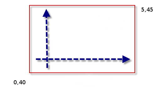
Then we put this information inside the Index.art file next to your Geotiff file.
 F32x4:
 {
 	Name:"Area"
	Value:"0,40,5,45"
 }

 Bool:
 {
 	Name:"Bathymetry"
 	Value:"true"
 }
The Heightmap.tif geotiff file format needs to be 16 bits uncompressed and may contains or not bathymetry info for underwater areas aside the mainland elevation data, set the Bathymetry accordingly.
The actual resolutions of our height maps files goes from 1800m/px the Basemap to 225m/px of the Europe Atlantic area.
Normally you need to increase this resolution in your Mods to mark the difference with the actual game height maps.
All the game and Mod height maps are ordered by resolution and merged to be used in game.
Also the first time a height map it’s read, we normalize his values, update the file, and marked as ‘backed’ inside the Index.art file.